

Most Everest Base Camp trek itineraries online are written by operators selling a tour, or by trekkers who walked the trail once a long time ago. Either way, the day-by-day misses the parts that really make the trip – like the Lukla flight, the lodges worth staying at (and the ones worth skipping), when to hike instead of rest, and which side trips earn the extra days.
I’ve walked the EBC route across multiple trips into the Khumbu. First as part of the full Three Passes loop, then back for the Gokyo Lakes and to summit Island Peak. Safe to say I know this trail pretty well, and I’ve watched it change over the years.
This guide breaks down the classic 12-day Lukla to Everest Base Camp and back, which is about 130 km (80 mi) total, maxing out at 5,644 m (18,519 ft) on Kala Patthar. You’ll get a route map, actual walking times and altitudes per day, named lodges I’d book, the parts I’d skip, and the side trips worth adding.
The EBC Route at a Glance: Map, Distance & Altitude
Before reading another word of the day-by-day, here's the route at altitude, on a map, and in numbers.

Everest Base Camp Route Itinerary
Here's the full 12-day Everest Base Camp trek itinerary at a glance. Below the overview, each day has the distance, real walking times, the lodge I'd book, and a "wish I'd known" note from my own time on the trail.
- Day 1: Fly Lukla, walk to Phakding (2,610 m / 8,563 ft)
- Day 2: Phakding to Namche Bazaar (3,440 m / 11,286 ft)
- Day 3: Acclimatization day in Namche - Khumjung + Khunde loop
- Day 4: Namche to Tengboche (3,860 m / 12,664 ft)
- Day 5: Tengboche to Dingboche (4,410 m / 14,469 ft)
- Day 6: Acclimatization day in Dingboche - Chhukung Ri (or Nangkartshang)
- Day 7: Dingboche to Lobuche (4,940 m / 16,207 ft)
- Day 8: Lobuche to Everest Base Camp and back, sleep at Gorak Shep (5,140 m / 16,864 ft)
- Day 9: Kala Patthar sunrise, descend to Pheriche (4,371 m / 14,340 ft)
- Day 10: Pheriche to Namche Bazaar (3,440 m / 11,286 ft)
- Day 11: Namche Bazaar to Lukla (2,860 m / 9,383 ft)
- Day 12: Fly Lukla back to Kathmandu

First: An Honest Expectation Reset
Probably good to get this out of the way early. Most people picture Everest Base Camp as a hardcore mountaineering experience. It's really not.
EBC is now the most popular multi-day trek in Nepal, with over 60,000 trekkers walking the route every year. The infrastructure that's grown around that demand has changed the trek beyond recognition - even compared to my first trip into the Khumbu. You don't camp, you sleep in proper tea house lodges with mattresses and dal bhat. You don't climb - there's nothing technical, no ropes, no crampons, no special skills required. It's just a long, high, extremely beautiful walk.
Combine that with the availability of guides, porters, charging points, hot showers, espresso, and satellite Wi-Fi from Namche upward, and getting yourself to base camp is much more of a fitness and altitude test than a mountaineering one.
That's not to take anything away from the trek itself. The Khumbu is one of the most jawdroppingly beautiful regions on earth and walking through it is something I'd happily do again tomorrow. But the expectation reality check is worth doing early - especially if you're trying to decide whether this is the right Nepal trek for you.

Less Crowded Alternatives in Nepal
If reading the words "60,000 trekkers a year" has put you off EBC, the good news is that Nepal has dozens of incredible multi-day trekking routes for every experience level - many of them quieter, less infrastructure-heavy, and arguably more rewarding than the standard EBC trail.
I've done a lot of trekking in Nepal across multiple trips, and these are the ones I'd recommend looking at first:
- Manaslu Circuit - the closest thing to what the Khumbu used to feel like. Stricter permits, fewer crowds, deeper cultural immersion.
- Three Passes Trek - the EBC trail plus three high passes (Kongma La, Cho La, Renjo La) and a full loop through Gokyo. The best trek I've done in the Himalaya.
- Gokyo Lakes Trek - same Khumbu region, much quieter side valley, alpine lakes and Gokyo Ri instead of Kala Patthar.
- Mera Peak - Nepal's tallest non-technical trekking peak at 6,476 m. A proper introduction to high-altitude mountaineering.
- Island Peak - 6,189 m peak that pairs naturally with EBC for anyone wanting a real summit at the end of the trek.
Tip: You can also bolt one of the high passes onto your EBC trek if you want a taste of all this without committing to the full Three Passes loop. More on that further down.

Altitude Profile: Lukla to Kala Patthar & Back

Worth a few seconds reading the chart properly, because the shape of it changes how the trek actually feels on the trail.
The first thing to notice is that the trail goes down before it goes up. Lukla sits at 2,860 m and Phakding at 2,610 m, because Day 1 is a descent into the Dudh Kosi valley before the climb begins. Day 2 then makes up for it with an 830 m gain into Namche.
The two flat-looking sections - Day 3 in Namche and Day 6 in Dingboche - aren't rest days. Both are acclimatization hikes that gain 400 to 700 m before dropping you back to your sleeping altitude. That's how proper altitude acclimatization actually works: climb high, sleep low.
The biggest jump on the chart is Day 8, where you go from Lobuche at 4,940 m up to Gorak Shep at 5,140 m, then on to EBC at 5,364 m and back. It looks moderate on the line graph - it isn't. It's the longest single day of the trek and you're working at over 5,000 m the entire time.
And finally, the highest point on this trek is not Everest Base Camp. It's Kala Patthar at 5,644 m, the rocky viewpoint above Gorak Shep that we'll hit on Day 9 before sunrise. From base camp itself you can't actually see Mount Everest's summit - the south face is hidden by the Khumbu Icefall and the surrounding peaks. That's why Kala Patthar is the real photo moment of the trek.
Note these details are based off my recommended Everest Base Camp trekking route itinerary. You can vary this of course.

Insurance for Trekking & Climbing in Nepal
Read the fine print– Most travel insurance companies void coverage as soon as you step over 5,000 m. That's why I use and recommend Global Rescue, as the best high-altitude trekking insurance (no altitude caps).
Day 1: Kathmandu (or Manthali) to Lukla, Hike to Phakding
- Trekking time: 3 hrs (after the flight)
- Distance: 8 km / 5 mi
- Elevation change: -250 m descent
- Sleeping altitude: 2,610 m / 8,563 ft (Phakding)
- Lodge: Trekker's Lodge, Phakding
Most Day 1 sections of EBC itineraries online start at Lukla airport, like the trek begins with the cinematic short-runway landing. In reality, in peak season, your day starts closer to 3 am on a minivan parked outside Thamel.
In the spring (April-May) and autumn (September-November) trekking peaks, the Nepalese government routes Lukla flights out of Manthali (Ramechhap) instead of Kathmandu. That means a 4 to 5 hour pre-dawn drive on rough mountain road before you even check in for your flight. It's grim, it's unavoidable, and the only way to skip it is to fly outside peak season - which most trekkers can't or won't do.
The flight itself is short - around 35 minutes - and on a clear morning the views across the Khumbu valleys make up for the early start.

For the flight, my pick is Tara Air (operated by Yeti Airlines). They run the most daily flights to Lukla, which matters because delays are constant and you want to be on the airline most likely to actually get you in the air. I've also flown Summit Air and Sita without issues. Book direct on the airline site rather than through an agent.
A quick word on the Lukla airport reputation: it's earned. I witnessed a plane crash here in 2019 - a Summit Air aircraft lost control on takeoff and clipped two parked helicopters. It was the flight scheduled before mine, off the same runway. Recent runway upgrades and stricter safety checks have helped a lot since then, but the "world's most dangerous airport" headlines aren't all hype.

Once you land, things get easier fast. The trail leaves Lukla immediately, dropping past Cheplung and down into the Dudh Kosi valley. Get the earliest flight you can - it gives you a clean morning to walk to Phakding before the afternoon clouds roll in. Hire a porter from the gaggle waiting at the Lukla gate if you haven't pre-booked one.

The walk itself is gentle and mostly downhill, taking around 3 hours at an easy pace. This is the only day on the trek where the trail loses altitude rather than gains it - you're descending into the Dudh Kosi valley before the long climb to Namche tomorrow. You'll cross a couple of suspension bridges, share the path with donkey and yak trains hauling supplies up the trail, and pass through a string of small Sherpa villages on the way.

I stayed at the Trekker's Lodge in Phakding - basic, clean, fair price. Several other lodges in town if it's full.
Wish I'd known: Don't stop for lunch on the way into Phakding. Push to your lodge first, drop your bags, then walk back into the village if you want food. The lodges that hawk lunch to passing trekkers aren't the ones you actually want to sleep in.
Day 2 - Phakding to Namche Bazaar
- Trekking time: 6 hrs
- Distance: 11 km / 6.8 mi
- Elevation change: +830 m gain
- Sleeping altitude: 3,440 m / 11,286 ft (Namche Bazaar)
- Lodge: Sagarmatha Lodge, Namche
If Day 1 was a gentle stroll, Day 2 is where the trek actually starts. You'll gain 830 m in altitude, cross five suspension bridges, and finish with a punishing climb up the hill to Namche Bazaar. It's the steepest sustained climb of the whole 12-day itinerary, and it'll tell you most of what you need to know about how your body is going to handle the next ten days.
The morning starts easy. You'll walk along the Dudh Kosi past a string of small Sherpa villages and into Monjo, where the trail enters Sagarmatha National Park. This is where you actually pay your park permit (NPR 3,000 + 13% VAT) - the checkpoint is right at the gate and processes you in a few minutes. In recent years they now want you to have your passport ready.

After Monjo, the trail drops to the river and starts hopping back and forth across the Dudh Kosi on a series of high suspension bridges. The biggest is Larja Dobhan - the famous "Hillary Bridge" hanging absurdly high above the river junction. It's spectacular and it's also one of the worst trail bottlenecks in the Khumbu. Donkey trains, yak trains, porters with stove-pipe loads, and EBC trekkers all funnel onto one single-file bridge. Cross it early in the morning if you want to keep moving - the queue only gets worse as the day goes on.

From the bridge, the trail climbs. Hard. The next 600 m of altitude come in a relentless series of switchbacks through pine forest with very little flat ground until you reach the Namche helipad. Take it slow - this is the first time most trekkers really feel the altitude start to bite. The good news is that on a clear day, about two-thirds of the way up, you get your first view of Mount Everest peeking out from behind Lhotse and Nuptse. It's worth stopping for.

Namche itself is a surprise. It's a full town - bakeries, gear shops, bars, espresso, an Irish pub. After Phakding, the scale of it is jarring.
I've stayed at a few different lodges in Namche over the years, but my pick is the smaller Sagarmatha Lodge up on the hill. Cleaner than most of the bigger places, and you can pick up a double serving of Dal Bhat for around 500 NPR. Expect to pay a bit more in the bigger lodges fronting the main square.
Tip: The Namche climb destroys people who try to push it. Take it 30 steps at a time, stop, breathe, repeat. Sherpas pass everyone slowly and steadily - copy them.
Day 3 - Namche Acclimatization Day (Khumjung + Khunde Loop)
- Trekking time: 4 hrs
- Distance: 6 km / 3.7 mi (loop)
- Elevation gain: +400 m peak (back to Namche to sleep)
- Sleeping altitude: 3,440 m / 11,286 ft (Namche Bazaar)
- Lodge: Same as Day 2 - Sagarmatha Lodge, Namche
The first thing to know about the "acclimatization day" in Namche is that you don't actually rest. The whole point of it is to gain altitude, hold it for a few hours, then drop back to your sleeping altitude - the climb-high-sleep-low principle that proper altitude acclimatization is built on. Sit in a bakery all day and you'll wonder why you feel awful the next morning.
So you hike. The single most worthwhile route from Namche is the Khumjung + Khunde loop, which gets you about 400 m above town to a couple of authentic Sherpa villages, one of the best Everest viewpoints on the entire trek, and a few worth-knowing cultural stops along the way.

The standard loop heads up the steep zigzag track behind Namche to the Syangboche airstrip (still technically active, but mostly used as a high helipad these days). From Syangboche it's a flat 30-minute walk to the Hotel Everest View at 3,880 m. The lodge itself is overpriced and the rooms aren't the point. The terrace is - on a clear morning you get one of the best views of Everest, Lhotse, and Ama Dablam on the entire trek, with a coffee that costs about four times what it should. Worth it.

From there, drop down into Khumjung, a proper Sherpa village set in a high valley. Two stops here are worth the time: the Hillary School (Edmund Hillary's gift to the Sherpa community, founded in 1961) and the Khumjung Monastery, which famously displays what locals say is a yeti scalp. Whether or not it actually is, the monks are friendly and the monastery is one of the more atmospheric stops in the lower Khumbu.
Continue across to the neighboring village of Khunde, then loop back down to Namche on a different track. Total time on the trail is around 4 hours at a relaxed pace, including a stop for coffee, a wander through the school, and a bit of monastery time.
You sleep in the same lodge as the night before, eat a big dinner, and your body spends the night quietly building the red blood cells you'll need for the rest of the trek.
Tip: Don't waste the Namche acclim day in a bakery. The number of trekkers I've seen "rest" in cafes on Day 3 and then struggle for the rest of the trek is too many to count. The hike is the rest - and the apple pies up at Khunde are way better!

Day 4 - Namche Bazaar to Tengboche
- Trekking time: 5 hrs
- Distance: 10 km / 6.2 mi
- Elevation change: +420 m net (with a descent and re-climb in the middle)
- Sleeping altitude: 3,860 m / 12,664 ft (Tengboche or Debuche)
- Lodge: A smaller lodge in Debuche, 15 minutes past Tengboche
The number on Day 4 lies a little. The official altitude gain is just 420 m, but the trail doesn't actually go up that gently. After about two hours of beautiful, mostly flat traverse from Namche, you'll drop almost 200 m down to the river crossing at Phunki Tenga, then climb close to 600 m straight back up the switchbacks to Tengboche. What looks like a 420 m day on the chart is more like a 600 m climb, with the river-and-back tacked on top.
That said, the morning is one of the best stretches of the lower Khumbu. The trail leaves Namche on the high traverse and contours along the side of the valley with constant views of Ama Dablam, Thamserku, and Kangtega off to the right. Take it slow - this is the kind of section that's wasted if you're putting your head down and powering through.
The descent to Phunki Tenga is steep, dusty, and a bit demoralizing because you know you'll have to climb it all back. There's a small cluster of lodges at the river for lunch - a fair pit stop if you've still got the energy. From there, the climb to Tengboche is hard but not technical: about two hours of switchback grind through pine and rhododendron forest until you crest the ridge into the village.
I've seen this place in every season, and on my most recent trip we got a beautiful blanket of snow - unreal!

Tengboche itself is small, but it's home to the Tengboche Monastery - the most significant Buddhist gompa in the Khumbu, built by Lama Gulu in 1916, destroyed twice (the 1934 Nepal-Bihar earthquake and a 1989 fire) and rebuilt both times by the local community. The afternoon prayer ceremony usually starts around 3 PM and visitors are welcome to sit at the back of the main hall. If you can time your arrival to make it, do. It's the most epic cultural moment of the whole trek.

My honest take on where to sleep: push past Tengboche to one of the smaller lodges in Debuche, 15 minutes further down the trail. The lodges there are quieter, the prices a bit fairer, and you sleep at almost the same altitude. The big EBC-trail lodges in Tengboche are fine but charge a Tengboche premium for what you get. If you've still got energy in the legs, you can keep going another 15 minutes past Debuche to Milinggo - even smaller, and arguably the most authentic lodging stop on the lower trail.
Tip: Time the day so you arrive at Tengboche Monastery before 3 PM, then walk on to Debuche after the ceremony. Most trekkers stay at Tengboche purely because that's what their itinerary tells them to do - the actual experience is better split between the monastery and the smaller village.

Day 5 - Tengboche to Dingboche
- Trekking time: 5 hrs
- Distance: 12 km / 7.5 mi
- Elevation change: +550 m gain
- Sleeping altitude: 4,410 m / 14,469 ft (Dingboche)
- Lodge: Cafe Himalaya, Dingboche
Day 5 is when the trek physically changes. You leave the last of the rhododendron forest behind, the trees thin out and then stop completely, and from here it's exposed high alpine all the way to base camp. The air feels different too - thinner, drier, and colder in the shade.
The morning starts gently. From Debuche, the trail contours along the Imja Khola valley past the village of Pangboche, where Ama Dablam suddenly fills the sky to the east. Worth a slow look - this is the closest you'll get to it on the trek. Pangboche is also the trailhead for the Ama Dablam Base Camp side trip if you're tempted to add an extra day - the trail starts right next to Sonam Lodge at the far end of the village.

Past Pangboche, the trail drops to a small bridge across the Imja Khola, then climbs up the other side onto a wide, treeless ridge. This is where the route splits: most operator itineraries send you north to Pheriche, but the smarter call is east up the side valley to Dingboche.
My honest recommendation is Dingboche, every time. Pheriche is fine, but it sits in a wind tunnel and the sun drops behind the ridge by around 3 PM. Dingboche is in a wider, sunnier basin, gets afternoon light until much later, has a better selection of lodges and bakeries, and it's the natural launching point for the better acclimatization hike tomorrow up Chhukung Ri (more on that on Day 6).

The walk into Dingboche from the river crossing is easy and gradual - about an hour of mostly flat trail to a small bridge, then another 30 minutes through stone-walled barley fields and into the village.
I stayed at Cafe Himalaya in Dingboche - I'd recommend it without hesitation. Small bakery, warm dining room, and a great deal: spend 300 NPR and you can charge your phone or electronics for free. Day-old bakery treats sell for 150 NPR. Nothing like a microwave-warmed apple pie after a day at altitude.
Wish I'd known: Drink twice as much water on Day 5 as you think you need. The high alpine air dehydrates you faster than the forest sections below, and a lot of the "altitude headaches" I've seen on the trail above Tengboche are actually mild dehydration, not AMS.

Day 6 - Dingboche Acclimatization Day (Chhukung Ri, Not Nangkartshang)
- Trekking time: 7 to 8 hrs (Chhukung Ri full round trip); 3 to 4 hrs (Nangkartshang)
- Distance: ~14 km / 8.7 mi (round trip via Chhukung Ri)
- Elevation gain: +1,100 m to peak (back to Dingboche to sleep)
- Sleeping altitude: 4,410 m / 14,469 ft (Dingboche)
- Lodge: Same as Day 5 - Cafe Himalaya, Dingboche
Like Day 3 in Namche, Day 6 isn't a rest day. Most trekkers head up to Nangkartshang Peak above Dingboche - a 5,083 m viewpoint reached in around two hours of straight uphill switchbacks. It's fine, but it's not the best acclimatization hike from this village.
The better call - and the one most operator itineraries don't even mention - is Chhukung Ri, the rocky 5,546 m peak above the small village of Chhukung. To get there, you walk east up the Imja valley from Dingboche for about two hours to Chhukung (4,730 m), drop your day pack at one of the lodges, then take the steep trail behind Makalu Lodge up to the Chhukung Ri viewpoint. The summit takes around two hours from Chhukung at a slow acclimatization pace. From the top you've got 360-degree views of Imja Tse (Island Peak), Ama Dablam, Baruntse, Lhotse, and Makalu - one of the best high viewpoints in the Khumbu.

The full round trip back to Dingboche is around eight hours of walking. It's a long day. But the altitude gain is more useful, the views are better, and it's a much stronger preparation for the high days ahead.
If eight hours sounds rough, the half-measure is to walk to Chhukung in the morning, do the easier hike to Island Peak Base Camp in the afternoon (gentler, 4,970 m, mostly flat), and overnight in Chhukung. That repositions you for either continuing back to the standard EBC trail to Lobuche the next day, or branching onto a much higher-difficulty option for serious trekkers.

That higher-difficulty option is the one I'd really recommend if you've got the legs. From Chhukung, instead of walking back to the standard EBC trail to Lobuche on Day 7, you can climb the Kongma La pass (5,535 m) and descend directly into Lobuche. It's harder, longer, less crowded, and skips the boring main-highway section entirely. You don't have to commit to the full Three Passes loop to do it - just one pass, one harder day, and a much more interesting Day 7. More on this in the variations and side trips section below.
Wish I'd known: Don't follow the crowd up Nangkartshang just because that's where everyone else is going. Chhukung Ri is twice the hike and twice the payoff. If you need a slow day, take a short walk to Chhukung and back, drink three liters of water, and go to bed early - anything in between is the worst of both options.

Day 7 - Dingboche to Lobuche (Through the Thukla Memorials)
- Trekking time: 5 hrs
- Distance: 12 km / 7.5 mi
- Elevation change: +530 m gain
- Sleeping altitude: 4,940 m / 16,207 ft (Lobuche)
- Lodge: Above The Clouds Lodge, Lobuche
Day 7 is the day the trek stops feeling like a walk and starts feeling like an expedition. You're now well above the treeline, the air is noticeably thin, the temperature drops fast in the shade, and the section you cross today contains the most emotionally heavy stretch of the entire trek - the Thukla memorial.
The morning starts with a gentle climb out of Dingboche up to the high ridge above town. From there it's a flat traverse along the side of the valley with views down the Imja Khola and across to Lobuche peak ahead. The trail here is wide, easy, and mostly empty in the early morning - get going by 7 AM if you want to walk it before the main EBC bottleneck rejoins from Pheriche.

After about two hours, the trail drops down into the small lunch stop of Thukla (also spelled Dughla) at 4,620 m. There are a handful of lodges and tea houses here, and most trekkers stop for a midday meal before the steep climb up. The garlic soup at any of them is definitely worth ordering - garlic is the traditional Sherpa altitude remedy and it works.
From Thukla, the trail climbs steeply for about 45 minutes up to the Thukla Pass at 4,830 m. This is the section worth slowing down for. At the top, you arrive at the Thukla memorial - a quiet plateau covered in stone chortens and cairns, each one built to honor a climber who died on Everest or one of the surrounding peaks. Some are unmarked, some have the climber's name carved into the stone, some have prayer flags strung above them. Scott Fischer, Babu Chiri Sherpa, and dozens of others are remembered here.

It's not a "don't miss" attraction. It's a moment. Take five minutes, walk the ground slowly, read some of the names. The trail to Everest takes lives every year, and this is where the people who walk it stop to acknowledge that.
From the memorials, the trail flattens onto a high moraine and traces the side of the Khumbu Glacier into Lobuche, around an hour and a half further on. Lobuche is small, basic, and cold - seriously cold. Layer up before you arrive and don't expect a warm bedroom.
For the lodge, my pick without hesitation is Above The Clouds Lodge at the back of the village. The owner is one of the most welcoming people I've met on the entire trail, the rooms are warmer than the rest of Lobuche's options, and trekkers who've crossed Kongma La get a free tea and a discount on lodging. It books out fast in peak season - either book ahead or arrive early.
Tip: Don't try to powerwalk through the Thukla memorial. It's the only stretch of the EBC trail that's not really there for you - it's there for the people who didn't come back. Slow down.

Day 8 - Lobuche to Gorak Shep, Then Everest Base Camp and Back
- Trekking time: 7 to 8 hrs
- Distance: 15 km / 9.3 mi (round trip)
- Elevation change: +424 m to EBC, then back 224 m down to Gorak Shep
- Sleeping altitude: 5,140 m / 16,864 ft (Gorak Shep)
- Lodge: Buddha Lodge, Gorak Shep
Most operator itineraries label Day 8 as the longest, hardest day of the trek. It's the slowest day, sure - you're walking at over 5,000 m the whole time and your body has every right to be cranky about it. But it's actually a pleasant walk if you let it be one. Slow it right down, and the trail isn't brutal at all. This is the day you've been working towards. Walk it gently and let it land.
The morning leaves Lobuche along the lateral moraine of the Khumbu Glacier - a strange, beautiful trail of grey ice rubble and small pinnacles, with the glacier itself cracking and shifting on your right. After about three hours of mostly flat walking with a couple of short rocky climbs, you'll drop into the sand bowl at Gorak Shep at 5,140 m.

Get your lodge sorted first. Gorak Shep only has a handful of tea houses and they fill up fast in peak season. Drop your big pack, eat something quick, then take a smaller day pack out for the walk to base camp in the afternoon. Buddha Lodge is a solid pick - food is steeply priced like everywhere else up here, but the dining room is warm and the rooms are clean.
The walk to Everest Base Camp takes about two hours each way along the Khumbu Glacier moraine. The trail is undulating and rocky, with some short ups and downs that feel harder than they should at this altitude. Take it slow, drink water constantly, eat a snack every hour. There's no easier way at 5,300 m - your body just does it slow.

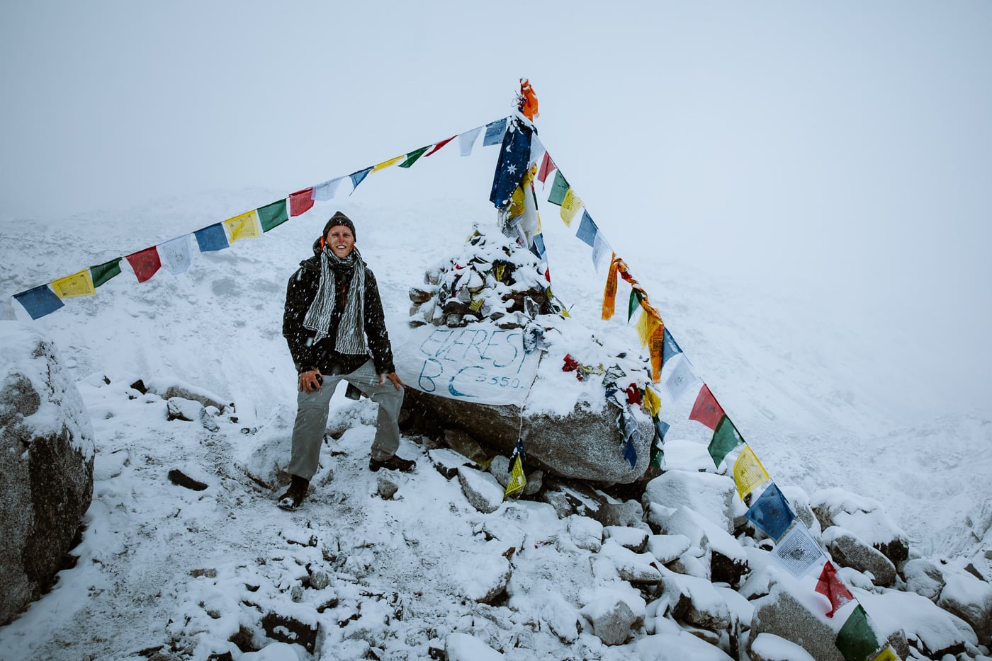
EBC itself sits at 5,364 m at the base of the Khumbu Icefall. In spring (April-May), you'll see the colored expedition tents of climbers preparing to summit Everest. There are a couple of stone chortens, and a famous painted boulder where most trekkers take their photo.
It's a strange place. You're standing at the foot of the most famous mountain in the world, and you can't actually see Mount Everest's summit from where you're standing - the south face is hidden behind the icefall and the surrounding peaks. The mountain you most want a photo of isn't visible until tomorrow morning at Kala Patthar.

That's not to take away from the moment. The Khumbu Icefall up close is properly humbling - a chaos of seracs and crevasses pouring down the mountain, the same icefall that climbers take on the first leg of an Everest summit attempt. Sit there for a while. Take it in. Then walk back to Gorak Shep before the late afternoon clouds roll in.


Back at the lodge, eat dinner early, drink water, layer up for the night. Tomorrow starts before sunrise.
From experience: Don't waste energy chasing the "perfect" EBC photo. Most of the iconic shots you've seen online are taken from Kala Patthar at sunrise tomorrow, not from base camp itself. The base camp moment is about being there, not the picture.
Day 9 - Kala Patthar Sunrise + Descent to Pheriche
- Trekking time: 7 to 8 hrs total (Kala Patthar pre-dawn RT + descent)
- Distance: 16 km / 10 mi (4 km up Kala Patthar + 12 km descent to Pheriche)
- Elevation change: +500 m to Kala Patthar summit, then -1,275 m descent to Pheriche
- Sleeping altitude: 4,371 m / 14,340 ft (Pheriche)
- Lodge: The Edelweiss Pheriche
Day 9 is the day. Kala Patthar at sunrise is the actual highlight of the entire EBC trek - the only place on the route where you get a clean, unobstructed view of Everest's summit, with alpenglow painting the south face gold for about 15 minutes after first light. I've climbed it twice, both at sunrise, and both times it was the photo I came home with.
Set an alarm for 4 AM. Layer up properly - it'll be -10°C or colder in the dark and the wind on the summit can be vicious. Eat a quick something, grab a head torch, and start walking. The trail starts at the sand bowl on the edge of Gorak Shep, climbs through switchbacks for the first hour, then steepens up the rocky outcrop to the prayer-flag-draped summit at 5,644 m. It takes around 1.5 hours at a slow pace.
Aim to be on top by around 6 AM. Sunrise hits Everest first - the south face turns a deep gold, then bright pink, then yellow as the sun climbs. From the summit, you've got panoramic views of Everest, Nuptse, Lhotse, Changtse, and Pumori. The colored EBC tents are visible far below, and the Khumbu Glacier coils away to the south. It's the trek's defining photo moment, and it is seriously worth the 4 AM start.

Why sunrise instead of sunset?
Two reasons. The alpenglow is dramatic in the morning, hits Everest first, and lasts about 15 minutes - the actual money shot of the whole trek. And mornings are usually clearer up here; the afternoon clouds roll in fast on this side of the valley, and a cloudy summit is the worst possible disappointment after climbing in the dark.

The descent from Kala Patthar takes around an hour back to Gorak Shep. Eat a real breakfast, pack up, and start the long walk down to Pheriche. The route retraces yesterday's trail back to Lobuche, then drops past the Thukla memorials and contours along the side of the valley to Pheriche at 4,371 m. Total walking time from Gorak Shep is around four hours.
Pheriche feels almost balmy after the altitude of Gorak Shep. The air is thicker, the temperature warmer, and your appetite suddenly comes back. For the lodge, my pick is The Edelweiss Pheriche - attached bathrooms (a luxury at this point in the trek), the warmest dining room in town, and food that's noticeably better than the bigger lodges nearby.
Tip for Kala Patthar Views: If the weather forecast for tomorrow morning is bad and the sky's clear right now, swap the schedule and do Kala Patthar this evening for sunset instead. Cloudy mornings are common in November - take a clean view when you can get it.
Day 10 - Pheriche to Namche Bazaar (Knees Scream Day)
- Trekking time: 6 hrs
- Distance: 15 km / 9.3 mi
- Elevation change: -931 m net descent (with one re-climb up to Tengboche)
- Sleeping altitude: 3,440 m / 11,286 ft (Namche Bazaar)
- Lodge: Same as Day 2 - Sagarmatha Lodge, Namche
Day 10 is the day your body remembers what oxygen feels like. Every hour of descent, the air thickens, your appetite comes back, and the trek goes from a slow uphill grind to a fast-feeling downhill cruise. It's also the day your knees and quads finally pay the bill for nine days of uphill walking, so don't get too cocky.
The route follows yesterday's descent line in reverse but extends much further. From Pheriche, the trail drops gently down the valley past Shomare, then merges with the main EBC trail near Pangboche. From there, you'll retrace Day 4 in reverse - through Pangboche, down to the river at Phunki Tenga, then back up the steep switchbacks to Tengboche.

The climb back up to Tengboche is the only real uphill on Day 10. It's about 250 m of ascent through pine forest, and at this point in the trek, your legs will not enjoy it. But it's also the last meaningful climb before Lukla, so push through. Grab a snack at Tengboche, take one last look at Ama Dablam, and start the long descent down towards Sanasa.
From Sanasa, the trail traverses back to Namche along the same high contour you walked on Day 4. This is the most enjoyable stretch of the day - mostly flat or gently descending, with constant views and the smug knowledge that the hardest part of your trek is behind you.
You'll arrive in Namche by mid-afternoon. Same lodge as before if it's available - the Sagarmatha Lodge on the hill - and a celebration is in order. Treat yourself to a proper meal, a hot shower (which actually feels hot at this altitude), and a beer at the Irish Pub if that's your thing. You earned it.
Tip: Don't over-pace the descent today. Most trekkers crash on the long downhills because their quads are shot from a week of uphill walking. Use trekking poles, take it easy on the steep switchbacks, and save your knees for tomorrow's descent into Lukla.

Day 11 - Namche Bazaar to Lukla (The Undersold Final Day)
- Trekking time: 6 to 7 hrs
- Distance: 19 km / 11.8 mi (the longest single-day distance of the trek)
- Elevation change: -580 m net (with a sting in the tail back up to Lukla)
- Sleeping altitude: 2,860 m / 9,383 ft (Lukla)
- Lodge: Paradise Lodge, Lukla
Day 11 is the day every itinerary undersells. "Walk back to Lukla" is what the operator pages tell you. What they don't mention is that this is the longest single-day distance of the entire trek, that it ends with a 250 m climb back up to Lukla that nobody warns you about, and that your body is by now badly out of shape for prolonged downhill walking.
The morning leaves Namche on the same steep switchback trail you climbed on Day 2, just in reverse. Take it slow on the way down - this is where most knees finally give out. The descent to the Hillary Bridge takes about 1.5 hours, and then you're back into the suspension bridge sequence along the Dudh Kosi.

From the Hillary Bridge, the trail mostly follows the river back through Monjo (where you'll hand the Sagarmatha National Park permit back in at the checkpoint) and on to Phakding for lunch. So far, so familiar. This is where it gets sneaky.

The walk from Phakding to Lukla isn't downhill - it's uphill. Lukla sits 250 m higher than Phakding, and the final stretch climbs steadily for about two hours through Cheplung and back up the ridge to the airstrip. After ten days of mostly walking up to the high mountains, your legs will not be expecting another climb. Take it slow. Eat something at Phakding before you push for it.
You'll arrive in Lukla by mid to late afternoon. Get a lodge sorted - Paradise Lodge is my pick, within walking distance of the airport gate, fair price, and the dining room is one of the warmest in town. Most lodges in Lukla are clustered around the strip, which is convenient for tomorrow's early flight.
The evening in Lukla is one of the stranger ones of the trek. You're back at low altitude, you can have a drink for the first time in two weeks, and the lodge bars fill up with trekkers who just walked off the trail. Some are flying out tomorrow, some are flying in tomorrow, and there's an interesting overlap of stories. Worth a beer, a real meal, and a slow wind-down. Then sleep early - the morning flight runs on Lukla rules.
Tip for the return flight: Don't book a same-day international flight out of Kathmandu for tomorrow. Lukla flights are the most weather-affected in Nepal, and delays can leave you stuck for days (as you can imagine we were the first time after the plane crash...). Build in at least one full buffer day in Kathmandu before any onward travel.

Day 12 - Lukla to Kathmandu
- Travel time: 35 min flight (or 35 min flight + 5 hr drive in peak season)
- Route: Lukla to Kathmandu, or Lukla to Manthali then road back
- Arrival altitude: 1,400 m / 4,593 ft (Kathmandu)
Day 12 is the day Lukla decides whether you go home on time. You don't.
The flight is scheduled for first light - usually before 7 AM - because afternoon clouds make the Lukla strip unflyable. In practice, this means a lot of waiting. Your flight might leave on time, it might leave 4 hours late, or it might cancel entirely and roll over to tomorrow. There's no pattern, no app, and no reasoning with the situation. Get to the airport early, bring snacks and a book, and accept the day will go how it goes.
In peak season (April-May, September-November), your flight will land at Manthali / Ramechhap rather than directly into Kathmandu. From there it's the same 4 to 5 hour minivan drive back through the foothills - bumpy, slow, and oddly more nerve-wracking than the trek itself. Outside peak season, you fly straight back to Kathmandu in around 35 minutes.

Either way, by mid-afternoon you should be back in Thamel, showered, fed, and unrecognizable from the version of you that walked out two weeks ago. There are plenty of great places to wind down in Kathmandu - my picks are a long sit-down lunch at Or2k for vegetarian food, a steam at one of the Thamel rooftop saunas, and a wander through Boudhanath at sunset if you've got an extra day or two.
Tip: build a buffer day - I'll say it again because it matters. Don't book your international flight for the same day as your Lukla flight. The Lukla flight is the single most weather-cancelled scheduled flight in Nepal, and being trapped in Lukla for an extra two or three days is a real possibility. Add at least one full buffer day in Kathmandu after your return - if everything goes smoothly, you've got a free day in the city, and if it doesn't, you don't lose your international flight.

Review: Is the EBC Route Worth Trekking Today?
The Everest Base Camp trek is bigger, busier, and more comfortable than it was on my first trip into the Khumbu. The lodges have wifi, the bakeries have espresso, and on a sunny morning you'll share the trail to Namche with a few hundred other trekkers.
Some people read all that and decide to do Manaslu instead. I get it.
But I keep coming back to the Khumbu. The Khumbu still has views you can't see anywhere else on earth, a culture that's woven into every bridge and chorten and prayer flag, and the kind of high-altitude landscape that recalibrates how you see big mountains forever. The trails are well-built, the people who run the lodges are genuinely generous, and the pacing of a properly built itinerary - climb high, sleep low, take the acclimatization days seriously - means most fit travelers will get to base camp without serious issues.
The EBC itself is overdone, yes. But you can still have an amazing trekking experience in the Khumbu if you alter your itinerary route a little (as I suggested in this article). You can walk the standard 12-day route, push through Kongma La for a harder Day 7, or add Gokyo and the full Three Passes loop for the longer version of this trip, you're walking through one of the great mountain landscapes of the world.
Oh, and if all this trekking seems too much but you want to see the highest mountain on earth. You can do it before your morning coffee by booking a a quick morning helicopter flight from Kathmandu - here's my review.
